Community Environment Government
Pierce County seeks public’s experiences with sea level rise amid increase in flooding
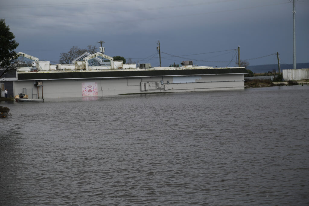
For many years, employees and customers alike can expect to find themselves wading through sometimes shin-deep water in the parking lot of the small cluster of businesses at the Purdy Spit at least once a year. Business owners have to prepare for store flooding, too, and the accompanying water damage.
The Spit is just one area of many in Pierce County to feel the impacts of climate change-driven sea level rise and increasingly dramatic and volatile king tides. But because of the scale of flooding and how populated the Spit business center is, it’s also one of the most visible and obviously affected areas. More subtle changes can happen in a back yard or crawlspace.
This is in part why Pierce County sent out a survey, so that planning officials can track and work on mitigating impacts of rising sea levels.

Flooding in Purdy in January 2024. Photo by Ed Friedrich
Gathering information about flooding
The three-question survey is part of Pierce County’s update to its Shoreline Master Program, which the state’s Shoreline Management Act 2029 update mandates, explained Pierce County Councilmember Robyn Denson. The update to the act has a new sea level rise subsection that requires public input.
“We hear from residents frequently when we’ve got king tides and storm events that they are having increased flooding that they’ve never experienced before onto their land, into their crawl spaces, over their docks, and doing damage and increasing erosion and damaging structures as well as natural environments,” Denson said. “The sea level rise survey to the community is just one step in this process, but it’s gathering a lot of really important super local information that the county may not have, that the big GIS studies that we have may not have.”
Pierce County’s survey asks how concerned the respondent is about sea level rise; whether they have experienced effects of sea level rise or know of anyone who has; and if they want to share anything about sea level rise that has not been addressed in the survey.
Flooding in Burley Lagoon in November 2024. Photo by Vince Dice
The survey also includes an optional mapping tool so respondents can show officials where they have seen or heard about sea level rise. Officials hope to use this tool to look for clustered areas of reported events or effects, as well as create a map of affected areas.
County planner Ansley Silva is with the Long Range Division in the Pierce County Department of Planning & Public Works, and is one of the officials working on the county’s strategy to address sea level rise.
Coastal squeeze
In addition to affecting homes and businesses, Silva said, sea level rise destroys habitats and ecosystems. This can happen through coastal erosion. That’s usually a natural process, but when exacerbated by sea level rise, one that can happen at an increased rate, particularly with strong or repetitive wave action that carries off rock, soil, sediment and sand. Loss of coastal habitat means other native animals and plants won’t have homes themselves.
Other animals can’t just leave the area, either, because existing development makes leaving these areas difficult, Silva said. This phenomenon is called “coastal squeeze.”
Saltwater intrusion is also a problem, Silva said. This is when saltwater migrates from marine areas onto land, like when high tides spill into areas of lower elevation or push into underground aquifers. It is possible to mitigate intrusion, but challenging to reverse it, once saltwater is in an aquifer.
People may also find standing water on their properties where there was none in previous years, Silva said. This is due to groundwater level rise from inward flooding pushing up the water table.
“We’ve seen standing water when there’s been a flood along the river in the floodplain area where it goes across the road or has flooded people’s yards,” Silva said. “So we can see this type of flooding even though before there might not be a surface water source.”
Sea level rise
The changes in sea level and its impacts are complex, Silva said, and include factoring greenhouse gas emissions and the effects of rising surface temperatures and ocean temperatures.
Earlier this year, the World Meteorological Organization confirmed that 2024 was the warmest year on record with “exceptional” land and sea surface temperatures. Ocean temperatures also rose, and played a major role in 2024’s overall temperatures. The last 10 years have also ranked as the top 10 warmest years on record.
And as the Earth’s temperatures rise, ice sheets melt, leading to overall sea level rise, particularly as land masses move around.
“There will likely be three feet of sea level rise by the end of this century, with some variability in certain locations,” Silva explained. “There’s vertical land movement that creates variability in the sea level rise. It might actually decrease in some little areas because the land is actually sinking on a geological time scale.”
Flooding growing more common
Right now, Silva said, severe flooding events are considered once-in-a-lifetime events. But by 2050, that could happen every year. Much of the world has already gotten a taste of that this year, with record numbers of flash floods across the globe that have claimed hundreds of lives.
Denson said that the county will work with a consultant to address the issues they discover.
“The more local information we have, the better the consultant’s report is going to be — the more local and really, really targeted to our area,” Denson said. “So that’s why it’s really important for people to fill this out and let us know what’s happening, because if they’re not reporting it to us, sometimes we don’t know what the impacts are in specific areas, on specific beaches, on specific spits, and we need to know that information because whatever’s happening now is going to continue happening later.”
You can find the county’s sea level rise survey here.