Community Education Environment Government
City board backs 1 of 2 requests from developer of project near Gig Harbor High
A 31-home subdivision proposed along the western edge of the Gig Harbor High School campus inched closer to reality last Thursday, April 24, at a meeting of the city’s Design Review Board. The all-volunteer panel voted to recommend approval of one of developer/owner Gig Holding Company LLC’s two requests for permission to deviate from standards stated in the city’s Design Manual.
The city also got a taste of the brewing opposition to the project. This came from people who attended and voiced their concerns about the project’s potential for damaging wetlands, increasing traffic congestion and destroying wildlife habitat.
The panel declined to endorse the developer’s proposal to reduce by 15 feet the width of the vegetative transition buffer required between the project site and the school district’s land. The standard calls for a 40-foot buffer.
But the board recommended approving the Texas-based developer’s request to increase the amount of fill it can bring onto the 38.63-acre plat, in order to lift the proposed building lots and roadway above their surroundings and facilitate drainage.
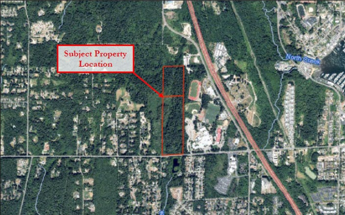
The proposed development, dubbed “Rosedale Plat” by the city, would occupy a long, narrow strip of land extending north from Rosedale Street. Neighborhoods of single-family homes and some rural uses border the site to the west, with undeveloped land to the north.
Wetlands
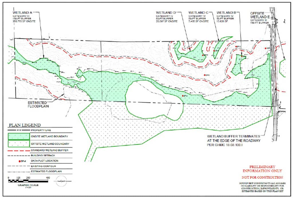
The land is swampy. A report prepared by city staff noted that “much of the site is encumbered by wetland and wetland buffers, a floodplain is located within the wetland and wetland buffer, and fill is required to meet stormwater management mitigation methods.”
Concern over the site’s wetlands, taken together with the developer’s request to bring in up to 60,000 cubic yards of fill, appear to be driving a vocal public reaction.

This site plan from Soundview Consulting, a firm working for developer/owner Gig Holding Company LLC, shows wetlands and wetland buffers in and around the Rosedale Plat site. The upper boundary of the parcel shown in the diagram is the border with the Gig Harbor High School campus.
In the weeks leading up to the Design Review Board meeting, the city received more than 25 written public comments on the project. Nearly all expressed concern over potential environmental damage, with worries about wetlands topping the list. A handful of people attended the meeting and expressed the same concerns during its comments period.
City officials noted several times during the meeting that it was not a forum intended to address habitat, wetlands or traffic issues.
Such matters “remain under active review by city staff. They are not the focus of tonight’s design review discussion, but they will be addressed in detail at a later stage,” said Jeremy Hammar, senior planner.
Future opportunities for public input will include an as-yet-unscheduled hearing on the project before the Gig Harbor Hearing Examiner, he noted.
Design deviations
The Design Review Board’s concerns are more aesthetic than environmental. It is charged with reviewing and interpreting the city’s Design Manual and with assessing permit applicants’ requests for alternatives to standards contained in that document.
These standards are “intended to identify and respect important visual patterns in Gig Harbor’s built environment and relate those to the natural backdrop of trees, hills and water,” according to the city’s website.
When an applicant seeks to deviate from Design Manual standards, the review board considers whether the proposed alternative represents an equivalent or superior solution, and whether it meets the intent of the general requirements of the manual. The board can recommend approval, disapproval or conditional approval. Its recommendations are not binding, but are intended to be considered by projects’ decision-makers (in Rosedale Plat’s case, the Gig Harbor Hearing Examiner).
In its plan for the site, Contour Engineering, the developer’s consultants, proposed reducing the width of the required vegetative buffer between the school district’s property and Rosedale Plat by 15 feet. This would help fit in a stormwater management facility and allow for larger rear yards in lots that back up against the eastern edge of the development, the engineering report noted.

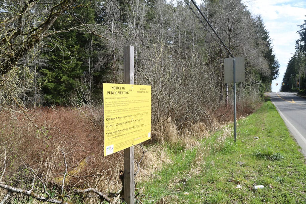
The proposed development would be located on vacant property along Rosedale Street adjacent to Gig Harbor High School.
School district opposition
The Peninsula School District opposed the narrower buffer.
“A reduced buffer would bring the proposed new homes much closer to a site that is actively used, increasing the likelihood that headlights from vehicles and lighting from both parking lots and athletic field lights will shine directly into the new homes,” wrote Patrick Gillespie, director of facilities and capital projects, in a letter to Hammar.
“Additionally, the sounds commonly associated with the operation of these schools and athletic facilities would be more prominent,” he wrote.
At the meeting, Design Review Board chair Darrin Filand noted that while school buildings now sit some 500 feet from Rosedale Plat’s proposed building lots, construction of future new facilities – such as a new high school – would likely bring them closer.
Board member Brianne Blackburn noted that the school parking lot near the proposed buffer “is busy, to say the least.” She said that for future Rosedale Plat homeowners, “more buffer is going to make happier neighbors.”
After some discussion, Filand informed Contour Engineering’s representatives at the meeting that if the board voted on the narrower buffer, “we probably would deny.” He recommended they withdraw that request and come up with a plan that allowed for a 40-foot wide buffer. The board did not vote.
Cut and fill
On the subject of excavating earth from higher areas of a development site (cuts) and adding dirt or other substances to lower areas (fills), the city’s Design Manual states that “cuts and fills on a site shall be balanced” and that “designs shall complement and take advantage of natural topography.”
In their report on Rosedale Plat to the Design Review Board, planning staff noted that the city “considers cuts and fills on a project to be balanced when cut and fill on site are within 10% of one another.”
But for Rosedale Plat, Gig Holding Company asked the Design Review Board to endorse an unbalanced approach.
The profusion of wetlands “limits the amount of available space for development” on the site, Contour Engineering wrote in a report filed with the city. The developer would not be able to “take material from unused portions of the site to help balance out the heavier fill portions as limited work is allowed within the wetland and wetland buffers,” it said.
“In this case, the site must be raised in order to stay above floodplain elevations while having very few high areas and mounds to borrow material from. This leads to a site which requires a significant amount of fill material to be brought in order for the site to be built upon.”

The property proposed for development is directly adjacent to Gig Harbor High School.
The engineers calculated that developing Rosedale Plat would require 46,475 cubic yards of fill, but asked the board to recommend approval for a maximum of 60,000 cubic yards in case the project’s needs changed.
Intent vs. letter of the law
Filand, the design board chair, noted that while the Design Manual calls for balancing cuts and fills, its section on that topic is headed “Maintain natural topography.” These words embody the intent of the requirement. The instruction to balance cuts and fills is better viewed as a means to achieve that goal, he maintained.
“You could cut a lot, you could fill a lot, you could really transform a property. That might meet the balance of cut and fill, but it’s not meeting the intent of what we’re talking about,” he said.
“In this initial proposal, I am not seeing a dramatic change in the grade elevation,” Filand said.
He added that “even though there’s not a balance in cut and fill,” the development plans are “not dramatically changing the landscape [and] I think it is an equivalent solution to what the Design Manual is looking for.”
The plan does not appear to call for filling in wetlands except where the road crosses over a narrow section, Filand said. In that instance, it provides for a culvert to allow the water through, he said. “In regard to where I think they’re putting fill, they are weaving their solution, in my opinion, around the identified wetlands.”
The four members of the 5-person board present at the meeting voted unanimously to recommend approval of the developer’s request to use up to 60,000 cubic yards of fill in the Rosedale Plat project.
